Buy the ROCK Triple-Band GNSS Network Base-Station HERE!
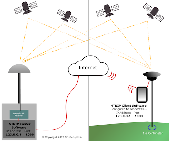
RTK (Real-Time Kinematic) positioning is a method used by an RTK-enabled GPS receiver to obtain extremely precise positions by using data from a RTK base station (ROCK Base Stations) (a second GPS receiver) that is transmitted over the internet. The NTRIP protocol (Networked Transport of RTCM via Internet Protocol) enables the mobile RTK GPS receiver (rover) to access data from the RTK base station over the internet to achieve 1cm accuracy.
An NTRIP service allows you to configure RTK using only one GNSS receiver acting as a rover. With the help of an NTRIP protocol, the service allows your rover to receive corrections from the nearest third-party base, a continuously operating reference station (CORS). This way, there is no need for you to have your own local base.
In order to access NTRIP services, you need to register and get a subscription. The cost and coverage area depends on your NTRIP service provider. ROCK RTK Network is $40 per month or $399 per year.
The benefits of using NTRIP over base/rover setups:
- Less equipment to carry in the field. Almost all data collectors, smartphones, and computers have the capability to connect to the internet even in a field setting. This also means you only need one GPS like the EMLID RS2+.
- Mitigate the chance of radio interference.
- No limitation on communication range. 900MHz, VHF, and UHF radios have a limited range.
The limits of using NTRIP:
- Requires the work area is in range of cellular service for receiving corrections data via the Internet.
- Does not work inside or under heavy vegetation
How does NTRIP work?
- NTRIP consists of two pieces of software which communicate over the internet. The server side runs NTRIP Caster software. This would be a CORS station or similar setup). The rover side runs the NTRIP Client software. This would be your Reach RS2+. The NTRIP caster is responsible for receiving the data stream from the base receiver and rebroadcasting it over a specified TCP (Transmission Control Protocol) port. This allows the Reach to get corrections from the network.
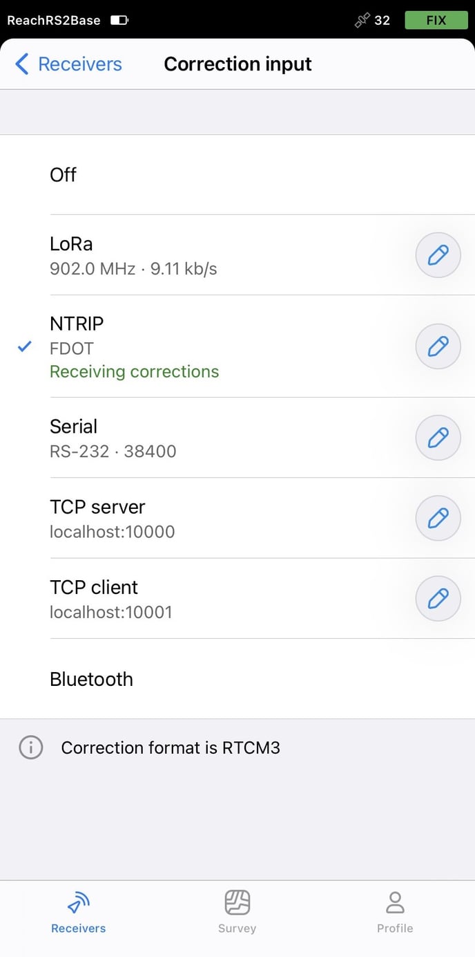
Adding an NTRIP Account to your Reach
- https://docs.emlid.com/reachrs2/rtk-quickstart/ntrip-workflow/
To find out which mount point suits you better, check the website of your NTRIP provider. The closer the mount point, the more precise your solution will be.
Capturing Points with your Emlid Reach via NTRIP
- Download the Emlid Flow App

- After setting up your NTRIP Profile in the app and ensuring you are connected to the internet, your unit should receive corrections and soon thereafter get a "FIX".
Setup your Survey Project in Emlid Flow
Make sure your GCP data is capturing in the same coordinate system as your deliverables need to be in!
Capture your points
- For GCP's try to capture them for at least a minute
- For the known point, try to capture it for at least 3 minutes
Always have a FIX when capturing points with this method and never use just a 1 second capture for any point. Averaging helps reduce error.
Export your points as a CSV
Format your points for import into PCMaster and ROCK Cloud
- Using Excel or Google Sheets, open the CSV
- For PCMaster: Use the Latitude / Longitude / Ellipsoidal Height values for the known point of your choosing
- You can copy and paste the Latitude and Longitude values into the PCMaster Prompt
- Make sure to note that if you are using a coordinate system based in FEET you need to convert that number to METERS before using in PCMaster. You will also need to add 2.134 meters to that value to compensate for a 2 meter pole and the Reach RS2 offset.
- For ROCK Cloud: Remove all the columns but the first 4 - Name Easting Northing Elevation (this may differ based on your coordinate system)
- Save As or Download the CSV to your project file
- Your points are ready to be uploaded to Rock Cloud as a CSV
- Here's how to import your GCPs to the ROCK Cloud