Revolutionizing ALTA Surveys: A Quick Guide to Enhancing Workflow with ROCK's LiDAR Technology
In the land surveying world, the execution of ALTA/NSPS Land Title Surveys demands absolute precision. Traditionally, this has meant a time-consuming process with potential for manual error. But the advent of drone LiDAR technology and advanced planimetric extraction software is dramatically changing the game. And leading this revolution is ROCK Robotic with its ROCK R3 Pro drone and ROCK Planimetrics solution.
The ROCK R3 Pro is a high-performance aerial LiDAR drone specifically designed to deliver professional-grade 3D point cloud data. Coupled with ROCK's SLAM technology, the R3 Pro merges aerial scans with handheld LiDAR scans to provide a comprehensive, 360-degree coverage of any project site. This detailed coverage significantly enhances the quality and accuracy of ALTA surveys, eliminating any guesswork.
But the revolution doesn't stop with data capture. The collected LiDAR data is transformed into actionable insights with ROCK Planimetrics, available on ROCK Cloud. ROCK Planimetrics automates the extraction of features from 2D orthomosaics or 3D LiDAR point clouds, turning raw data into detailed, easy-to-understand planimetric maps. This automation of feature extraction for ALTA surveys saves countless hours, reduces the chance of errors, and increases overall project profitability.
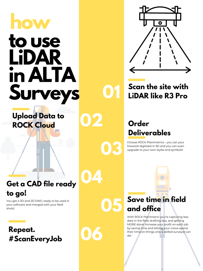
1. Preparation: Equip yourself with a ROCK R3 Pro or a high-quality mapping drone.
2. Capture: Combine aerial and handheld LiDAR scans for comprehensive data.
3. Process: Utilize ROCK Cloud for precise Planimetrics.
4. Maximize: Finish jobs quicker, improve accuracy, and boost your profits.
5. Repeat: Apply this workflow to every job for consistent, high-quality results.
Combining the advanced data capture capabilities of the ROCK R3 Pro, the seamless integration of SLAM, and the automated feature extraction of ROCK Planimetrics, ROCK Robotic is elevating the standard for ALTA surveys. The result is a faster, more precise, and more efficient ALTA survey process.
Experience the future of ALTA surveys with the ROCK R3 Pro and ROCK Planimetrics. Join the revolution and witness how LiDAR technology and automated planimetrics can elevate your surveying practice. To learn more or schedule a demo, contact us at hello@rockrobotic.com. Don't just survey; soar with ROCK Robotic.

ROCK R3 Pro, LiDAR drone, SLAM technology, 3D point cloud, ROCK Planimetrics, ALTA surveys, land surveying, 2D orthomosaics, automated feature extraction, ROCK Cloud.