My Ground Control Points are in the Ocean
This is nearly always caused by a swapped x and y or an incorrect Ground Control Point Coordinate (GCP) Reference System (CRS).
Debug steps:
Swapped x and y:
- Swap the x and y coordinates within the ground control point pane and save. See if that solves the issue. If not, continue.
Incorrect GCP CRS:
- Navigate to https://epsg.io
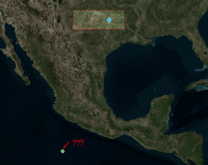
- Search for the CRS that you believe the GCPs are in. In the above example I have it configured for EPSG 6584 with the following GCP.
.png?width=655&name=Watters%20and%20Exchange%20Construction%20100922%20-%20Copy%20_%20ROCK%20Robotic%20Cloud%20(2).png)
When looking at the coordinates that show up in the x and y fields at the top of epsg.io map page, I can see that my entered coordinates in the Rock Cloud are nowhere close.
Rock Cloud:
32.652167, -97.447883
Epsg.io expected coordinates:
2288746.219195, 6923866.659317
This tells me that the coordinates that I entered in the Rock Cloud are not in EPSG: 6584. They are in some other CRS.
The next step would be to figure out what CRS these coordinates are in. Normally, if the coordinates look like a lat/long, then they will be in EPSG: 4326. In this situation, 32.652167, -97.447883 looks like a lat/long. Let's test it out:
Bingo! These coordinates are in WGS 84 (EPSG: 4326). You may not get this lucky. But, with some experience, you should be able to determine what CRS your GCPs are in for your area. Alternatively, you can ask the surveyor that supplied the GCPs to you for the EPSG code.
Now update the GCP projection in the Rock Cloud and check to make sure the GCP shows up in the right spot.