Altitude and Speed
Flying at about 50m (164 ft) AGL and 5-6 m/s (11.2-13.4 mph) is the optimal speed and altitude for getting sub 5 cm (1.97 in) vertical accuracy.
The higher and faster you fly, the less accurate the readings of the sensor will be. However, there are more factors at play than just height and speed.
The reflectivity of the surface you are scanning also plays an important factor. Some surfaces have a harder time reflecting back to the sensor than others. For instance, we did a scan over some transmission lines in the desert:
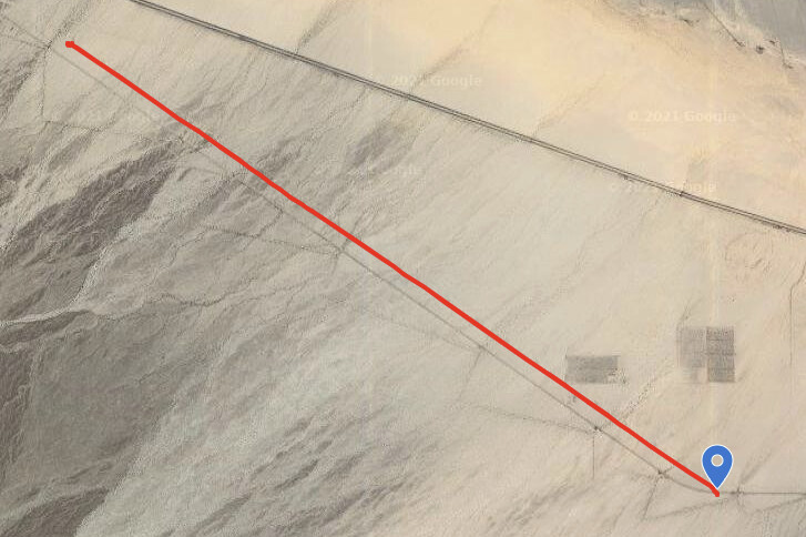
We were able to fly much higher and faster and still get sub 5 cm vertical accuracy because the surface reflected the light back to the sensor extremely well.
Overlap
The overlap you need will depend on the type of objects/terrain you are trying to collect. For general topography where you don't need trees or towers, a low amount of overlap is required. However, if you are flying a transmission line or doing tree canopy work you need those taller objects in the field of view of the laser so you'll need a larger amount of overlap.
| Application | Scan Height | Overlap | Speed |
| General Topography | 400ft (120m) | 30% | 8 m/s |
| Survey-Grade Topography | 200ft (60m) | 30-50% | 6 m/s |
|
Transmission Corridors |
200 -225ft (60-75m) | >60% | 6 m/s |
|
Substations |
150ft (50m) | >60% | 6 m/s |
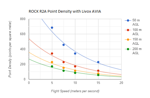
Point Density
The point density you will achieve depends on your speed and altitude. For rough estimates see the below chart to gauge how fast and high you can fly to get the point density you need in your project data.