 Here we will discuss the importance of point clouds in LiDAR surveying projects and how they are used to produce accurate and detailed results.
What is a Point Cloud?
A point cloud is a collection of data points representing the shape and location of an object or surface. These data points are typically collected using LiDAR sensors, emitting laser pulses that reflect off the target surface and return to the sensor. The sensor then records the distance and angle of each laser pulse, which is used to calculate the location of each data point in 3D space.
Why Are Point Clouds Important?
Point clouds are important because they provide highly accurate and detailed data that can be used for various applications. For example, point clouds can be used to create digital elevation models (DEMs) and digital surface models (DSMs) that can be used for land-use planning, flood risk assessment, and other applications. Additionally, point clouds can be used to create 3D models of buildings, bridges, and other structures for architectural and engineering design.
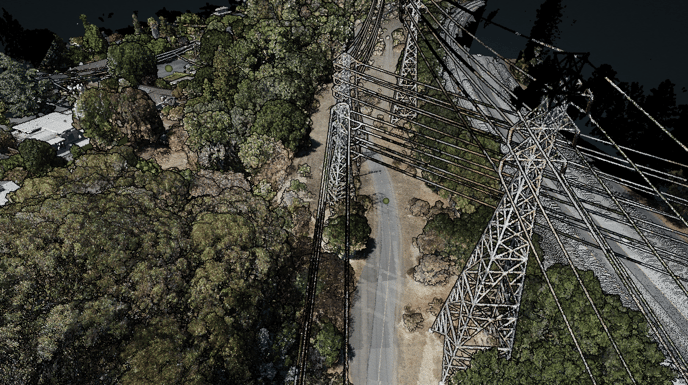
LiDAR Point Clouds
LiDAR point clouds are generated using LiDAR sensors, which emit laser pulses that reflect off the target surface and return to the sensor. The sensor then records the distance and angle of each laser pulse, which is used to calculate the location of each data point in 3D space.
LiDAR point clouds are known for their high accuracy and precision, making them ideal for surveying and mapping applications, and for creating detailed digital elevation models (DEMs) and digital surface models (DSMs). LiDAR point clouds can also penetrate through foliage and clouds, making it possible to survey and map large areas of forests, mines, and coastal areas.
Photogrammetry Point Clouds
Photogrammetry point clouds are generated using photographs taken from the air or ground, which are then processed using specialized software to extract 3D information. Photogrammetry point clouds are generated by comparing multiple images of the same scene, which allows for the calculation of the position and orientation of each point.
Photogrammetry point clouds are known for their high resolution and texture information, making them ideal for creating 3D models of buildings, bridges, and other structures, as well as for architectural and engineering design. Photogrammetry point clouds also allow for generating orthomosaic and 2D maps.
Accuracy is Key
Accurate point cloud data is essential in an aerial surveying project. It is the foundation for creating precise and detailed maps, efficient analysis, cost-effective decisions, safety, and informed design and planning. A project can be executed precisely and confidently with accurate point cloud data, providing essential information for architects, engineers, and other professionals.
Inaccurate point cloud data can lead to errors in the final product, making it difficult to use the data for decision-making or design purposes, increasing costs, and putting workers at risk. It also can hinder the ability to make informed decisions about a project, such as identifying potential safety hazards and assessing the environmental impact of a project.
Visit rockrobotic.com to learn more about ROCK Robotic's survey-grade LiDAR hardware and software.