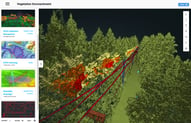
Today we are introducing a new way to do vegetation management, we call it vegetation management On-Demand. The ROCK cloud takes 3D point clouds from LiDAR and rapidly analyzes the data. Finding the locations and measurements of vegetation that is encroaching on your powerline assets. The data is quickly communicated in 3 useful ways:
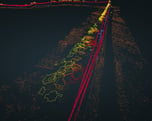
- Classified LAS point cloud - viewable on the ROCK Cloud viewer or downloadable fo 3rd party software.
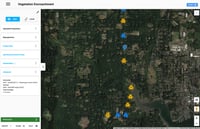
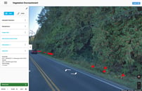
- Map icons - viewable on the ROCK Cloud map viewer and ROCK street viewer. Easily click on an icon and get google maps directions to your phone!
- SHP Files - Viewable on ROCK Cloud and Direct import into ESRI and GIS software
How Does it Work?
Step 1: Upload
The Vegetation Management APP takes in unprocessed LiDAR data captured by drone, helicopter, or airplane. In the above example, the data was captured using the ROCK R2A LiDAR system. The data is in LAS format. Create a new project and upload the LAS data.
Step 2: Reproject and ADD GCP
A common step to all LiDAR processing is to reproject the LiDAR data into a local coordinate system. First, define the current projection of the uploaded LiDAR data. Second, reproject into your destination projection. Then, add any ground control points and corresponding projection information. Once you have added GCP and reprojected the LiDAR project, you can use the LiDAR viewer and align your dataset with GCP points by following this article: Align to your GCPs.
Make sure to click the save icon on the LiDAR viewer after making any adjustments!!! Also, make sure all projection and adjustments are correct before moving onto the next processing steps. Adjustments can not be made after processing!
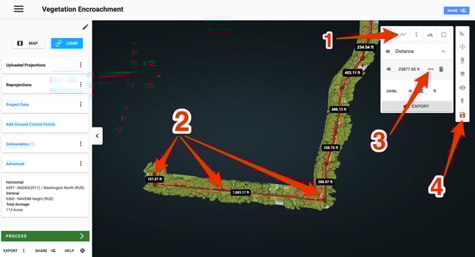
Step 3: Define Centerline
Now that the data is ready to be processed, simply select the centerline of the area to be processed. This centerline is used in calculating the cost of the Vegetation Management APP. Don't worry about being 100% accurate, we will check your work ;)
Create a centerline by using the Measure Distance tool. Then click and select your centerline. Once you have the area of interest selected, click the "Make Centerline" icon to the right of the measurement. Lasty, click save.
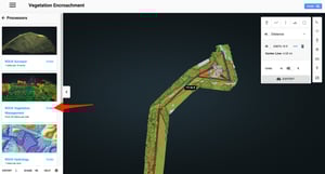
Step 4: Process and Deliverables
This next step is where the magic happens! Click "PROCESS" and select the ROCK Vegetation Management APP. Pricing will be displayed and you can submit your order! Now Sit back and relax while your deliverables are being prepared!
Bulk pricing is available as well as project based pricing.
Contact: sales@ROCKrobotic.com
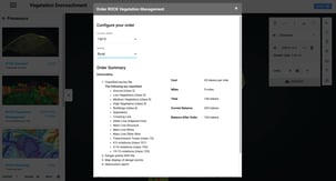
Pricing
The Vegetation Management is priced per mile and width. The pricing starts at $400 per mile. Please contact sales@ROCKrobotic.com for bulk pricing and per project pricing.
Quality Control/Quality Assurance
At ROCK, we understand that each project is vital and mistakes can't happen. Each project goes through the A.I. engine and is then verified by an engineer at ROCK robotic. If there is any issues with your data, please contact support@ROCKrobotic.com and we will get it fixed!