Stockpile volumetrics measures the volume of a stockpile, typically a pile of materials such as gravel, coal, sand, or ore. This process is used for inventory management, production planning, cost estimation, and other purposes. The volume of a stockpile can be measured using various methods, such as manual measurements, ground-based surveying, or aerial surveying using drones equipped with LiDAR sensors.
Using Photogrammetry or LiDAR
The most common method for stockpile volumetrics is to use photogrammetry techniques, which involve taking aerial photographs of the stockpile and processing them using specialized software to extract 3D information and calculate the volume of the stockpile. Another method is using LiDAR sensors, which emit laser pulses that reflect off of the target surface and return to the sensor. The sensor then records the distance and angle of each laser pulse, which is used to calculate the location of each data point in 3D space. With these data points, a point cloud is generated, which can be used to create a 3D model of the stockpile and calculate its volume.
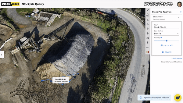
Do you want an easy way to calculate stockpile volumetrics? ROCK Cloud offers easy stockpile analysis. Read more here.
Measuring stockpiles using drone LiDAR can be helpful in several ways:
- Efficiency: Drones equipped with LiDAR sensors can quickly and accurately measure large stockpiles of materials, such as gravel, coal, or ore, from the air. This can save time and resources compared to manual measurements or ground-based surveying methods.
- Safety: Measuring stockpiles using drones eliminates the need for workers to access the stockpile, reducing the risk of accidents or injuries. This can be especially beneficial for stockpiles located in remote or hazardous areas.
- Cost-effective: Measuring stockpiles using drones can save money in the long run by reducing the need for expensive and time-consuming manual measurements or ground-based surveying methods.
- Accurate Volume Measurement: LiDAR sensors can provide high-resolution point clouds that can be used to create detailed 3D models of stockpiles. These models can be used to accurately measure the stockpile volume, which is crucial for inventory management, production planning, and cost estimation.
- Detection of Changes: Regular measurements of stockpiles using drone LiDAR can detect changes in the shape and volume of the pile over time. This can be used to detect unexpected extraction, track production, and manage the flow of the material.
- Better Planning: Accurate stockpile measurement can also be used to plan and optimize the extraction and production processes, such as identifying areas of high-grade ore or planning for reclamation of the site.
Accurate measurement of the volume of stockpiles can help companies optimize their operations and make informed decisions about their production, inventory, and costs.
Visit rockrobotic.com to learn more about ROCK Robotic's survey-grade LiDAR hardware and software.